A Long Cloud
There are countless ways in which a day can become a “good day”. Today was a good day because I saw a very long cloud.
A Cloudwatching Adventure
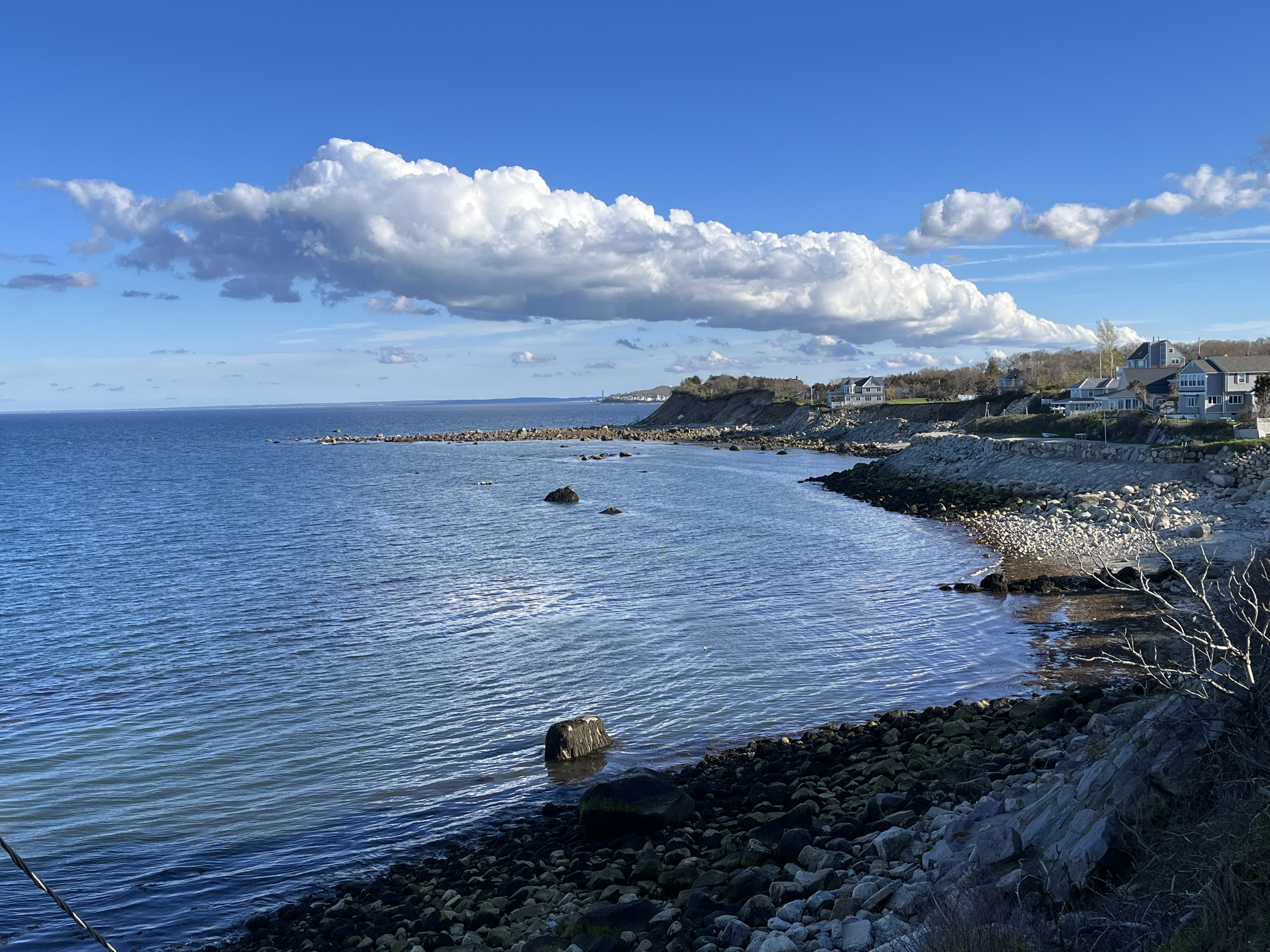
I was gazing southeastward at Cape Cod Bay from Manomet, MA, a small town southeast of Plymouth that juts into the bay and offers panoramic views of both the ocean and the atmosphere. There was a solitary cumulus cloud gently roiling before me, almost stationary despite weak but persistent southwesterly winds. Its character struck me as odd: it had the appearance of a stratocumulus cloud (being much longer than it was tall), but this cloud was all alone over the bay, unlike typical stratocumulus, which are most often gregarious and join in patches that can cover the entire sky. I had a great time filming a timelapse of this lone cloud, watching nooks and crannies appear and disappear in the beautiful fluid flow. (At the end of this post, I’ll talk about some of the features I saw in the cloud.)
As I was watching this cloud, I noticed a new cumulus cloud developing just upwind (meaning to the southwest, in this case, because that is the direction from which the wind was blowing). This second cloud was in the early stages of its growth, while my cloud of study was firmly in its golden years, finally dissipating after a lively career of moving air up and down. I relocated to Manomet Point for a better view of the new cloud, giving it a bit of time to develop. The view from the point showed a cumulus cloud whose southwesterly end was obscured by trees in the distance. A pretty long cloud! But this horizon was only a couple miles away, so it probably only extended that far, right?
Then, the plot thickened: a friend sent me a picture of a long, narrow cloud. But she had spotted this cloud in Falmouth, 20 miles to the southwest. Could it be?… Lo and behold, satellite imagery confirmed that we were seeing the same cloud: this cumulus cloud was 20 miles long! I realized that I was seeing one end of a liquid snake that stretched far beyond my horizon, basking in the sun for as long as it could manage before dusk fell. This Long Cloud (now warranting capitalization) had provided a tiny element of unity between the lives of those of us who were looking at the sky this afternoon and wondering what this funny cloud was up to.
The above video shows satellite imagery of cloud cover over southeastern Massachusetts from about 5:00 to 6:30 pm. The Long Cloud grows and decays over the course of the video, stretching from Falmouth in the southwest to Cape Cod Bay in the northeast at its peak serpentine glory around the 17:59 timestamp. The prelude cloud from the timelapse at the end of this post can also be seen in this satellite imagery: it is present at the beginning of this video by the eastern exit of the canal and propagates northeast over Cape Cod bay as it rapidly dissipates. Visualization is from Windy using Eumetsat data. (The “jerkiness” is due to interpolation, where images taken at discrete times, probably about 10 minutes apart, are smoothed into a continuous video.)
Why This Cloud?
When I see a cloud, I always want to understand why it formed (such questions feel almost compulsive at this point). Answering the question in this case isn’t fully straightforward, but there are clues we can use to make a good guess. The first impulse is to see if such a cloud appeared in our weather model forecasts for today. But that’s not possible, because this feature is actually quite small from a model perspective: while 20 miles sounds like a long distance to us, only our highest resolution weather models can properly simulate such distances. And that’s the long direction of the cloud! So we can forget about seeing this cloud directly in a forecast. Then let’s think more generally. The cloud is long and narrow, far away from other features. That character suggests it is associated with an atmospheric front, where characteristics change rapidly over a short distance. (This would be a small-scale front, rather than the large-scale warm and cold fronts you may be more familiar with.) In this case, the feature that’s changing rapidly is likely the wind direction, such that wind is blowing toward the cloud from either side. This pile-up of air beneath the cloud will force the air to rise along the line of convergence, condensing water and creating a cloud at the boundary. Indeed, the National Weather Service discussion this morning forecasted a line of convergence in southern New England, and the few wind observations I checked support this hypothesis. The cloud is also fairly aligned with the land-sea border between Buzzards Bay and the Upper Cape, suggesting that a sea breeze circulation could be at play, where the difference in temperature between the ocean and the land cause air to rush from the former to the latter, enhancing the wind convergence and cloud formation. These explanations satisfy me for now, but if you have any more information, send me an email!
Timelapse of the Prelude Cloud
This video shows timelapse imagery of the initial cumulus cloud over Cape Cod Bay. The timelapse is about 30 minutes in real time, from approximately 5:00 to 5:30 pm.
I love cloud timelapses because they let you see all the motion that’s just barely too slow for our eyes to register. A cumulus cloud that’s vigorously growing (let’s say at a rate that would let it reach from the ground to the cruising altitude of a typical passenger plane in about 20 minutes) will change in a way that’s just barely perceptible if one stares at the cloud by eye. But a timelapse brings all of the action to life, augmenting our eyes with “slow vision” that lets us watch clouds in their native timescales. Here are a few of the features that I was looking at as the prelude cloud (the one that foreshadowed the Long Cloud) developed before me:
- There is strong wind shear at the top of the cloud. Look how much faster the very top of the cloud moves to the left relative to the bottom of the cloud (especially see the middle of the cloud around seconds 0-5). This means that the wind is moving faster just above the cloud than just below it.
- Focus on the darker area under the cloud. Look at the left side and see how new cloud appears from below, especially from seconds 5-10. I think this is air that is being forced upward by wind convergence, forming fresh cloud.
- The upper portion of the cloud grows from around seconds 10-15, darkening and growing fuzzier as water droplets grow. It billows outward and upward, likely the result of an updraft within the cloud.
- There is strong evaporation on the underside of the cloud from seconds 12-16, where the dark portion of the cloud suddenly becomes ragged and disappears. This seems to be associated with the previous updraft. This decouples the main cloud from the recently-formed thin layer below. Does the evaporation happen because the saturated air is moving upward, or was there a downdraft that brought in dry air? I’m not sure, but it sure is cool.
- A new cumulus cloud develops at the end of the timelapse: it can be seen around seconds 20-22 on the right side. Notice the bright white color and the sharp outlines of this growing stage. This becomes the northeastern tip of the Long Cloud that made my day.